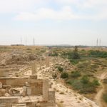
Lepcis Magna
loading map - please wait...
Historical background
By N. Carayon and S. Keay
According to the ancient sources, Lepcis Magna or Leptis Magna, also called Neapolis by some ancient Greek authors, was founded by the Phoenicians from Sidon (Sallust, Bellum Iugurthinum, 78, 1) or Tyre (Silius Italicus, III, 256; Pliny, N.H. V, 76) during the tenth century BC (Di Vita 1969; Carter 1965). The earliest occupation levels found in the vicinity of the Old Forum on the western side of the Wadi Lebda, however, are dated to the seventh century BC onwards. The city fell under the control of Carthage when it became a major western Mediterranean power during the sixth century BC, down until its defeat by Rome at Zama at the end of the Second Punic War in 202 BC. The city then became part of the kingdom of Numidia, but allied with Rome during the Jugurthan revolt (112-105 BC) (De Miro 2002).
During the Civil War of the mid 1st c BC, Lepcis Magna supported the cause of Pompey and in order to punish the city, Julius Caesar imposed upon it a heavy fine of 3 million pounds of olive oil. The city underwent a major period of development under Augustus and his successors, eventually becoming a municipium in c. AD 74-77 (Mattingly 1995: 116-22). In AD 110, during the reign of Trajan, Lepcis became the Colonia Ulpia Traiana Fidelis Lepcis Magna. At some time during the 1st or 2nd c AD the city was defined on its south, west and eastern sides by a substantial earthwork that enclosed an area of c. 425Ha. The city reached its apogee in the period following the accession to the throne of Septimius Severus, a native of the city, in AD 193. He conferred upon it the status of ius italicum in AD 203, and set in train a massive enlargement to the city that was still unfinished when the building programme was formally dedicated by Caracalla in AD 216 (Kenrick 2009: 91).
Following the administrative reorganization of the provinces of the Roman Empire by the Emperor Diocletian (AD 284-305), the city became the capital of the new provincial of Tripoliatnia, under the control of a praeses et comes in c. AD 303. Shortly after this date, Lepcis was surrounded by a new defensive circuit that enclosed an area of 130Ha, considerably less than previously. While the city was still a focus of vigorous activity during the course of the 4th c, by the time of the Byzantine “reconquest” in AD 533, the area enclosed within the walls had diminished to c. 44Ha, an index of the gradual decline in its importance during the 5th and early 6th c AD. It is likely that historically attested events, such as raids by the Austuriani in the mid 4th c and the conquest by the Vandals by c. AD 455 helped undermine the agricultural prosperity of the town.
Archaeological background
By N. Carayon and S. Keay
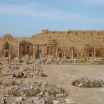
The earliest levels at Lepcis Magna has been documented in excavations at the site of Old Forum; this lies on the western side of the Wadi Lebda close to the coast and three offshore islands. The oldest horizon (level 4) contains Phoenician material that is dated to ca. 650 – 500 BC, and is suceeded by “Punic” and “Neopunic” levels dating to ca. 500 – 241 BC and ca 241 – 118 BC respectively (De Miro and Polito 2005). Surviving structures in this area developed from the 1st c BC onwards, and included the temples of Liber Pater and Rome and Augustus and other structures that opened onto a forum square of trapezoidal shape (Kenrick 2009: 109-114). Focused upon this early nucleus to the city was a gridded urban layout that followed the line of the Wadi Ledbda southwards, and which was adorned with a range of major public buildings during the reigns of Augustus, Trajan, Hadrian, Antoninus Pius and Marcus Aurelius, including a theatre, chalcidicum, public baths, monumental arches, amphitheatre and circus (Kenrick 2009: 87-133). The embellishment of the city begun by Septimius Severus, however, dwarfed these in terms of their scale and richness and included a new forum, basilica and temple complex, as well as a colonnaded street, a quadrifrons arch (Ward-Perkins 1993) and an enlargement of the harbour.
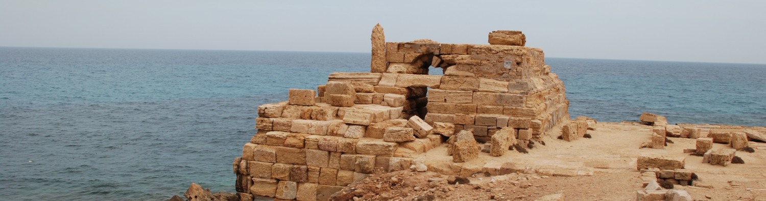
The very well preserved port of Lepcis Magna has been the subject of survey and excavations since the 1950s (Bartoccini 1962; Bartoccini 1961; Bartoccini 1958; Bartoccini and Zanelli 1960; Laronde 1994; see also Kenrick 2009: 126-9). In its earlier phase of use it comprised an embankment running along the western edge of the Wadi Lebda, that stopped short of the three offshore islands, and which was monumentalized under the reign of Nero. The surviving structures of the harbour largely date to a very substantial enlargement under Septimius Severus. His ambitious enterprise involved the creation of an inner basin of c. 13 Ha that is silted up today, and into which flowed the Wadi Lebda. This was defined by monumental quays that incorporated the two offshore islands lying to the west of the line of the Wadi Lebda, and the third lying to east – leaving an entrance in-between. The construction of a third quay beyond the eastern quay effectively created a second, outer, basin. The remains of stone mooring rings are visible along the western and eastern quays of the inner basin, while a lighthouse still stands at the northern end of the western quay, and warehouses survive along the eastern quay together with a temple and signalling tower. A temple to Iupiter Dolichenus stands in the southern side of the inner basin, while a temple of Flavian date overlooks the western side of the harbour.
Geomorphological background
By N. Carayon
The ancient city of Lepcis Magna is located on a littoral plain that opens on to the Gulf of Syrte, and which is defined by the Wadi Lebda to the east and the modern town of Al Khums to the west. The site of the ancient harbour is sited on the eastern side of the city and at the mouth of the Wadi Lebda. It is silted up today, possibly as the long-term consequence of the construction of a flood prevention dam further up the wadi at some time during the 1st or earlier 2nd c AD (Kenrick 2009: 90). The dam ruptured, possibly during the fourth century AD, leading to the silting up of the harbour-basin with the sediments carried down the wadi (Beltrame 2012; Laronde 1994).
Importance in the Roman harbour network
By N. Carayon
The development of the initial Phoenician and Punic city under Augustus and the Julio-Claudians with the construction of an artificial port, underlined the importance of Lepcis Magna within the area of Tripolitania. It played an important role in supplying the City with olive oil from the Gebel that was carried in Tripolitana I and 3 amphorae. At the Mediterranean end of the caravan routes from the African interior, Lepcis Magna was also a nodal point in order to supply Rome and its empire with exotic and luxurious products, including wild beasts for the arenas of Rome. Under the Severan dynasty the city and the port were transformed into one of the most beautiful cities of the Roman Empire. It is a very important case-study for Roman port infrastructures and planning in the late second century AD.
References
- Bartoccini, R. 1958. Il porto romano di Leptis Magna. Bolletino del Centro Studi per La Storia dell’Architectura, supplement 13. Roma.
- ———. 1961. “La Missione Archeologica Italiana nel porto di Leptis Magna. La V Campagna 1958.” In Atti del Settimo Congresso Internazionale di Archeologia Classica III. Rome.
- ———. 1962. “Il porto di Leptis Magna nella sua vita economica e sociale.” In Hommages à Albert Grenier, Vol. I, 228–43. Latomus 58. Bruxelles.
- Bartoccini, R., and A. Zanelli. 1960. Il porto romano di Leptis Magna. (Roma): Centro studi per la storia dell’architettura.
- Beltrame, C. 2012. “New Evidence for the Submerged Ancient Harbour Structures at Tolmetha and Leptis Magna, Libya.” International Journal of Nautical Archaeology 41 (2): 315–26.
- Bullo, S. 2002. Provincia Africa: le città e il territorio dalla caduta di Cartagine a Nerone. “L’Erma” di Bretschneider.
- Carter, T. H. 1965. “Western Phoenicians at Lepcis Magna.” American Journal of Archaeology 69 (2): 123–32.
- De Miro, E. 2002. “L’emporio Fenicio Punico di Leptis Magna ed i suoi sviluppi in età romana dai recenti scavi.” In L’Africa Romana. Lo spazio marittimo del Mediterraneo Occidentale: Geografia Storica ed Economia. Atti del XIV Convegno di Studio, Sassari 7-10 Dicembre 2000, 403–14. Roma: Carocci.
- De Miro, E., and A. Polito. 2005. Leptis Magna. Dieci anni di scavi archeologici nell’area del Foro Vecchio. I livelli fenici, punici e romani. Roma: “L’Erma” di Bretschneider.
- Di Vita, A. 1969. “Le date di fondazione di Leptis e di Sabratha sulla base dell’indagine archeologica e l’eparchia Cartaginese d’Africa.” In Bibauw (ed.), Hommages à Marcel Renard III, 196–202. Collection Latomus 103. Bruxelles.
- Haynes, D. 1946. An Archaeological and Historical Guide to the Pre-Islamic Antiquities of Tripolitania. Tripoli
- Kenrick, P. 2009. Lybian Archaeological Guides:Tripolitania. London: Silphium Press.
- Laronde, A. 1994. “Nouvelles recherches archéologiques dans le port de Lepcis Magna.” Comptes Rendus des Séances de l’Académie des Inscriptions et Belles-Lettres 138 (4): 991–1006.
- Mattingly, D. 1995. Roman Tripolitania. London. Batsford.
- Tantilloo, L. and Bigi, F. 2010. Leptis Magna. Una città e le sue inscrizioni in epoca tardoromana. Cassino.
- Ward-Perkins J. 1993. The Severan Buildings of Leptis Magna. London (ed. P. Kenrick).
Images