Leptiminus
Historical background
By N. Carayon ans S. Keay
According to Sallust (Bellum Iugurthinum, 19, 1-2), Leptiminus was founded by the Phoenicians at the same time as Hadrumetum (modern Sousse) and Hippo Diarrhytus (modern Bizerte). The earliest traces of occupation are, however, dated to the 6th c. BC and have been observed in two cemeteries located two kilometres of the ancient city (Fantar 1999; Gsell 1920, 135–136; De Smet 1913; Foucher 1967). Leptiminus seems to be mentioned in a mutilated passage of the Pseudo-Skylax (§ 110) dating to the 4th c. BC, and the port is also recorded as having been used by Hannibal Barca on his return from Italy to Africa in 203 BC (Livy, 30, 25, 12). Shortly after the sack of the Carthage in 146 BC, the inhabitants of the city, the Leptitani, are mentioned as a free people by Appian (Libyca, 94) and the city is referred to as an oppidum liberum by Pliny (HN 5.25). During the Civil Wars of the mid 1st c BC, Leptiminus welcomed Caesar’s garrisons and the sea around the city was the site of a naval skirmish (Bellum Africanum, 7, 2 and 29, 2). In 47-46 BC the city became a civitas libera et immunis and issued its own coins under Augustus. It has been argued that the city was granted colonial status under Trajan (Gascou 1972; Beschaouch 1991; Aounallah, Ben Abdallah, and Hurlet 2006), with the title of Colonia Ulpia Lepti Minus.
The economic and political apogee of Leptiminus was reached between the 2nd and the 6th centuries AD. Its eventual decline may have been due to a number of factors, including the gradual silting-up of its port, the impact of the arrival of the Vandals in the 5th c. AD and the subsequent reconquest by the Byzantines in the 6th c. AD. The date of the final abandonment of the town is still uncertain. While the latest coins from the site are issues of Constans II (AD 643-659), early Islamic pottery and coins are absent (Stone, Mattingly, and Ben Lazreg 2011, 18).
Archaeological background
By N. Carayon and S. Keay
Since the 19th c onwards, the remains of the ancient Leptiminus have been visited, described and excavated by numerous scholars. A preliminary account of these visits and early reports on major monuments at the site was published in the first volume of the reports of the joint Tunisian and American Leptiminus project in 1992 (Ben Lazreg, Mattingly, and Caciagli 1992, 9–62). Since 1990, the Leptiminus Archaeological Project has conducted a regional survey of the area and undertaken several excavations; since 1999, it has been run under the auspices of the INP and the University of Manitoba. The first results of this multidisciplinary project have been published in three volumes (Ben Lazreg, Mattingly, and Caciagli 1992; Stirling, Mattingly, and Ben Lazreg 2001; Stone, Mattingly, and Ben Lazreg 2011).
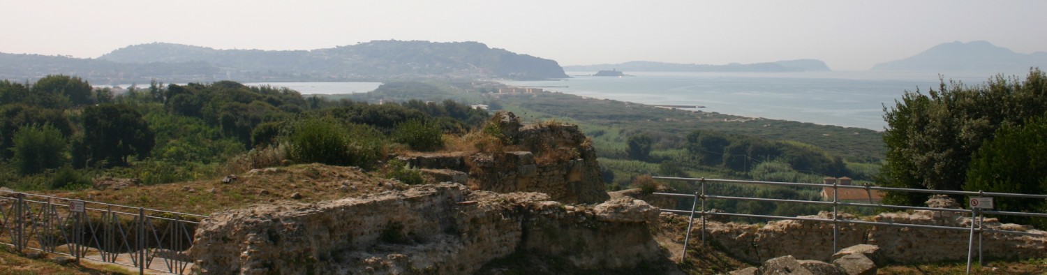
During the Punic period (5th-2nd c. BC), the likely focus of the settlement seems to have been located on the so-called “citadel hill”. Between this and the ancient shoreline, which now lies underwater, there is no archaeological evidence for any ancient occupation. There were, however, three cemeteries, situated to the west, south-west and at south-east of the settlement that provide the best evidence for its Punic and Libyan population. The possibilities for harbour infrastructure on this exposed seashore were limited, and boats were probably drawn up out of the water onto the beach of the Wadi Bou Hajar. No traces of rural occupation dating to this period have been found in the immediate hinterland of the port.
The transformation of the Punic settlement into a Roman town that covered c. 24 Ha seems to have involved the re-planning of the urban core on the citadel hill along orthogonal lines. Repeated common building alignments suggest that there were three phases of expansion down from the hill toward the shore and the port area, which had a 450 m long jetty that dates to c. the 1st c. BC – 1st c. AD, or slightly later (Stone, Mattingly, and Ben Lazreg 2011, 273–274; Davidson 1992). A public bath complex and the earliest aqueduct in Leptiminus seem to have been built during this period as well, perhaps dating to AD 93/94 according to brick stamps of Agathobulus and Cn. Domitius Tullus. Amphora production is also attested at the port, while Pliny mentions that fish products were exported to Rome (NH 31, 94). Extensive cremation cemeteries were established to the south-east and south-west of the town and rural settlement have been detected in the immediate hinterland.
The 2nd to 4th c. AD marks the apogee of the town. It is a period that saw a further major extension of the town eastwards, meaning that the built-up core of Leptiminus now covering c. 45 ha, with a concomitant increase in activity in the suburbium – an overall area of c. 150 Ha. Several public buildings date to this period: the amphitheatre during the 2nd or 3rd c. AD, together with dense construction along the western bank of the Wadi Bou Hajar, and the eastern Baths in the Severan period. Amphorae, African Cooking Wares and coarse wares were produced in large quantities and the iron could well have been produced on a large scale too. Roman burials occur in all known Punic cemeteries while a new cemetery was established along the south side of the city core in the late 2nd-early 3rd c. AD. The suburbium witnessed the appearance of various suburban villas and workshops. It is difficult to know whether the prosperity of the city continued into the 4th c. AD. One of the excavated kilns was abandoned at the end of the 2rd c. AD, but other industrial activity is attested elsewhere well into the 4th c. AD.
Geomorphological background
By F. Salomon and N. Carayon
The ancient city of Leptiminus in the Sahel region of Tunisia, occupies a small cape on the bay of Monastir within the Gulf Of Hammamet. It is defined to the west by the mouths the Wadi el Masourah and the Wadi Bou Hajar and to the east by a small bay which is itself limited to the east by a small promontory where the modern town of Lamta is located. The shore is low and sandy and the sea is shallow: indeed the 5 m isobath is located two kilometres from the coast. The area to the south is limited by small hills upon which were sited ancient cemeteries and quarries (Slim et al. 2004, 154; Fantar 1999, 23).
Indices of post-Roman erosion are evident in the cliffs and mosaic floors partially destroyed by the waves. To the west, it is possible that there was a progradation of the coast on account of the sediment carried down through the wadis, but this needs to be confirmed. According to Stone et al. (2011), the presence of submerged archaeological structures suggests that the sea-level has risen c. 50-75 cm since antiquity. Previous research at Leptiminus suggests that the modern shoreline was up to c. 200 m further inland than it was during Roman period (Slim et al. 2004, 154; Stone, Mattingly, and Ben Lazreg 2011, 142).
Importance in the Roman harbour network
By N. Carayon and S. Keay
During the mid to late Roman Period, Leptiminus was an important port that played a key role in the export of agricultural products from its immediate hinterland and indeed beyond (Mattingly, Stone, and Ben Lazreg 2001). The long harbour jetty, which enabled goods to be loaded onto cargo ships, demonstrates how artificial harbour infrastructure could transform what was a relatively small town into a highly important port within port networks that criss-crossed the Roman Mediterranean. In addition, communities in the suburbium of Leptiminus was devoted to the manufacture of amphorae, coarse wares, African Red Slipware, tiles, metal work, as well as the processing of fish into a range of food supplements. This meant that city effectively faced in two directions: inland towards its hinterland where agricultural goods were produced, but also out to sea and ultimately to markets across the Mediterranean and Rome itself.
References
- Aounallah, S., Z. Ben Abdallah, and F. Hurlet. 2006. “Inscriptions latines du Musée de Sousse, I. Lamta, Lepti(s) Minus.” Africa 21: 151–66.
- Ben Lazreg, N., D. J. Mattingly, and R. Caciagli. 1992. Leptiminus (Lamta): A Roman Port City in Tunisia. Report No. 1 . Journal of Roman Archaeology. Supplementary Series 4. Ann Arbor, M.I.
- Beschaouch, A. 1991. “Colonia Ulpia Lepti Minus.” In A. Mastino, a cura di, L’Africa Romana: Atti dell’8 Convegno di Studio , 14-16 Dicembre 1990, Cagliari (Italia)., Edizioni Gallizzi, 1:107–16.
- Davidson, D. P. 1992. “Survey of Underwater Structures.” In Ben Lazreg, N., D. J. Mattingly, and R. Caciagli, Leptiminus (Lamta) : A Roman Port City in Tunisia. Report No. 1: 63–75.
- De Smet, J.-J. 1913. “Fouilles de sépultures puniques à Lemta.” Bulletin archéologique du Comité des travaux historiques et scientifiques, 327–42.
- Fantar, M.H. 1999. “Villes-Ports de Byzacène avant la conquête romaine.” In La Méditerranée : L’homme et La Mer, dans le cadre du projet national mobilisateur : Les villes-ports en Tunisie, 13–51. Cahiers du CERES., Série Géographique 21. Tunis.
- Foucher, L. 1967. “Sur une fouille de Bou Hadjar.” Cahiers de Tunisie 57-60: 135–46.
- Gascou, J. 1972. “Lepti Minus, Colonie de Trajan?” Antiquités Africaines 6: 137–44.
- Gsell, St. 1920. Histoire ancienne de l’Afrique du Nord. Tome II. L’état carthaginois. Paris: Hachette.
- Mattingly, D. J., D. L. Stone, and N. Ben Lazreg. 2001. “Leptiminus (Tunisia): A ‘producer’ City?.” In D. J. Mattingly and J. Salmon (eds.) Economies beyond Agriculture in the Classical World, 66–89.
- Slim, H. P. Trousset, R. Paskoff, and A. Oueslati. 2004. Le littoral de la Tunisie : Etude géoarchéologique et historique. CNRS éditions. Etudes d’Antiquités Africaines. Paris.
- Stirling, L. M., D. J. Mattingly, and N. Ben Lazreg. 2001. Leptiminus (Lamta). Report No. 2, The East Baths, Cemeteries, Kilns, Venus Mosaic, Site Museum and Other Studies. Journal of Roman Archaeology. Supplementary Series: No. 41. Portsmouth, R.I.
- Stone, D. L., D. J. Mattingly, and N. Ben Lazreg. 2011. Leptiminus (Lamta). Report No. 3, The Field Survey. Journal of Roman Archaeology. Supplementary Series: No. 87. Portsmouth, R.I.